Complete Asset Visibility
Inside and Out
3D Laser Scanning and Concrete Mapping
Modern structural engineering cannot rely on assumptions. Whether you are rehabilitating a Grade I listed heritage site, re-engineering a complex industrial facility, or verifying the structural integrity of a commercial asset, you need absolute data certainty. You need to know exactly what exists within the physical space, and exactly what is hidden beneath the surface of the concrete.
The Cost of Spatial Assumptions
Traditional surveying methods and legacy 2D “as-built” drawings are fundamentally inadequate for complex engineering projects. Buildings settle, undocumented modifications occur, and original construction tolerances drift. When project teams rely on outdated blueprints, the result is spatial clashes, fabrication errors, and catastrophic clashes with hidden utilities or reinforcement during the construction phase.
Discovering a structural misalignment or a hidden post-tension cable after works have commenced leads to immediate project paralysis. In Tier 1 engineering, the cost of an avoidable strike or a delayed fabrication far outweighs the investment in accurate upfront data.
Engineering the Digital Twin
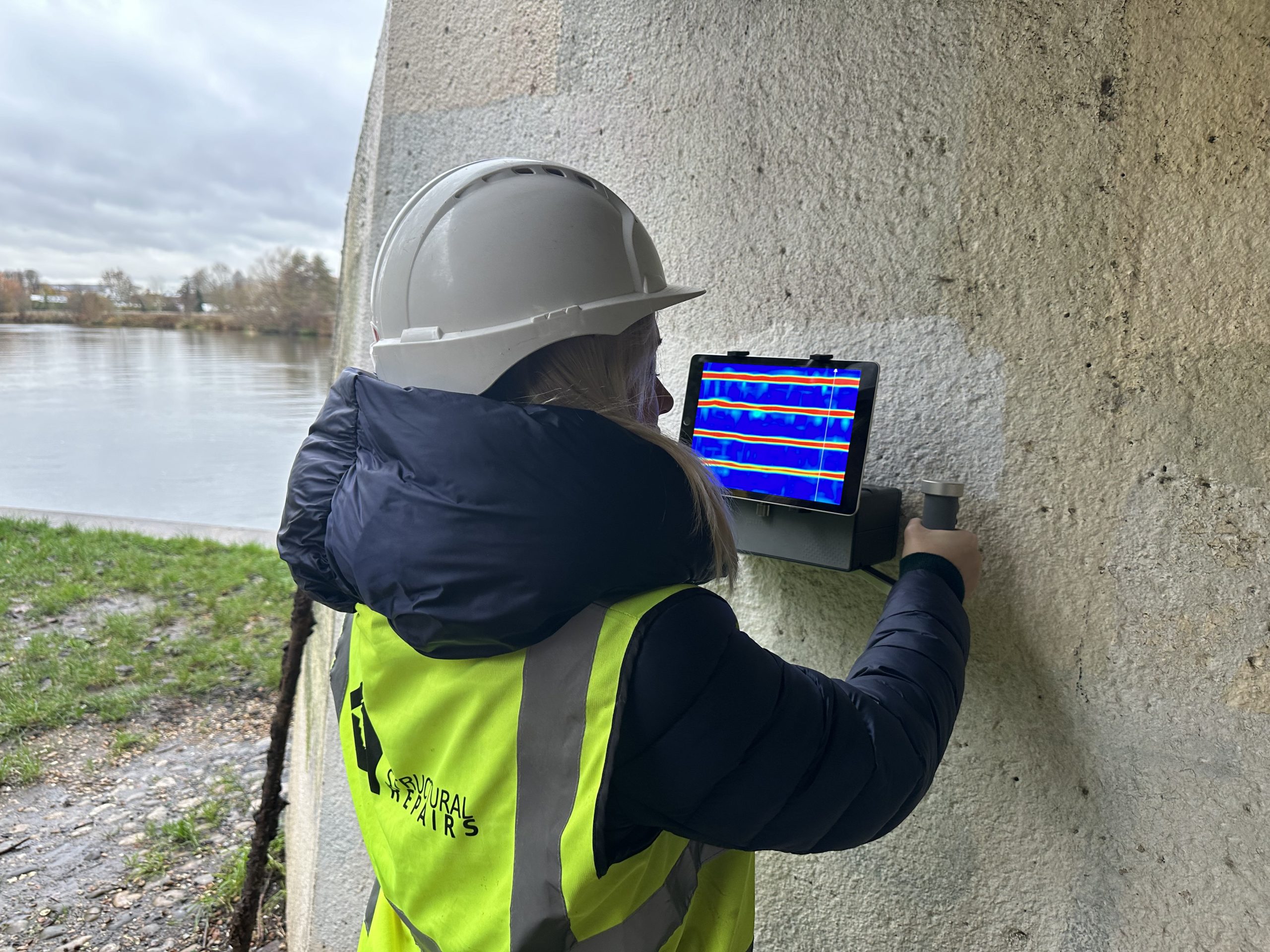
Structural Repairs bridges the gap between the physical structure and your digital design environment. We deploy a dual-technology approach, combining terrestrial 3D laser scanning (LiDAR) with advanced subsurface concrete scanning (GPR) to capture the complete reality of your asset.
Our laser scanners capture millions of precise data points per second, generating a high-fidelity, 3D point cloud of the environment. Simultaneously, our GPR technicians map the internal matrix of the concrete slabs and columns. By combining these datasets, we provide a true “Digital Twin” of your structure. This millimetre-accurate spatial data can be fed directly into your BIM (Building Information Modelling) or CAD software, allowing your architects and engineers to design bespoke strengthening systems, fabricate precise components, and plan complex structural interventions with zero margin for error.
Scanning & Spatial Mapping FAQ
A 3D laser scan uses LiDAR technology to rapidly measure the distance between the scanner and physical objects in its line of sight. It captures millions of individual measurements, creating a highly detailed, colourised 3D digital representation of the space, known as a point cloud.
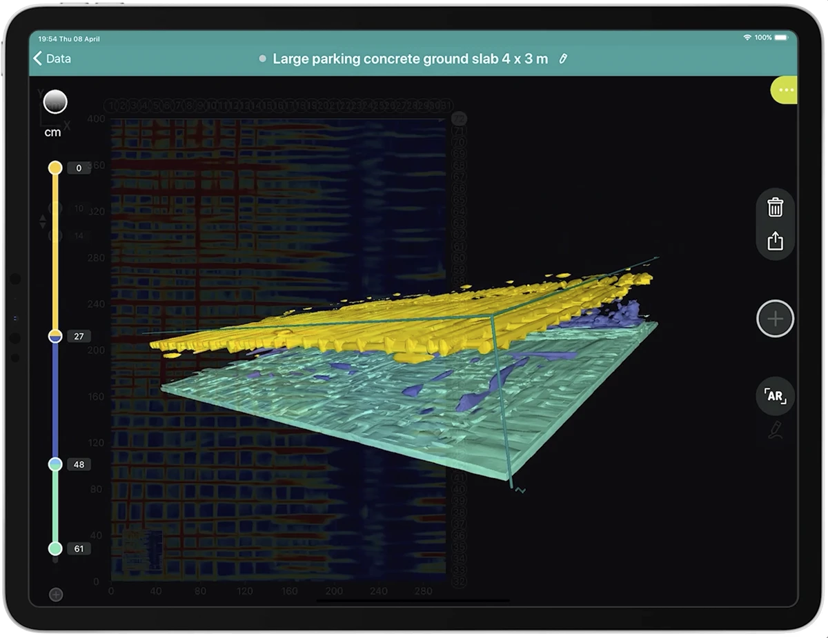
While a laser scan captures the exact surface geometry of a structure, concrete scanning (using Ground Penetrating Radar) detects the rebar, voids, and utilities hidden inside it. By combining the two, we can map the exact 3D coordinates of hidden subsurface elements relative to the physical space of the room or building.
Our high-end terrestrial laser scanners capture spatial data with sub-millimetre accuracy. This level of precision is critical for structural monitoring, reverse-engineering heritage components, or designing bespoke steelwork and carbon fibre strengthening systems.
Yes. The point cloud data we generate is fully exportable in industry-standard formats (such as .RCP, .E57, or .LAS). Your engineering and architectural teams can import this data directly into Revit, AutoCAD, or Civil 3D to serve as the foundational layer for all future design work.
No. 3D laser scanning is a completely non-intrusive, contactless process. It can be conducted in live environments, active construction sites, and operational facilities without disrupting your daily operations or causing structural damage.